Loading report
Please wait while we load the sample report…
Please wait while we load the sample report…
Sample report
This preview uses mock property details and extra demonstration overlays so you can see zone “spotlight” cards, compact standards tables with Unitary Plan deep links, and design-committee style notes together.
Important: figures, overlays, and some planning notes below are show data — they may be wrong, incomplete, or made up for layout. Always verify against the operative Auckland Unitary Plan and a current LIM before making decisions.
Check your own propertyHomeowner Zoning Report
Report generated: 6 July 2026
Zone
Residential - Single House Zone
Low Intensity
Max Height
8 Meters
Approx. 2 Storeys
Land area
780 m² (from valuation)
Total floor area
185 m²
Building Site Coverage
164 m²
Land Use
Residential Dwelling
Property Category
Residential
Rateability
Rateable
Legal Description / Title
Lot 8 DP 900001
Land District
Auckland
Local Board
Maungakiekie-Tamaki
Valuation Reference
SAMPLE-VALUATION-001
Property Status
Current
Record of Title
SAMPLE/123
Planner Note
What the available information shows:
This fictionalised sample property is suitable for a cautious renovation or modest extension, but flood plain context and public stormwater assets should be checked early.
What this could mean for your project:
The main sample risk is water: mapped flood plain context, nearby flood-prone areas, and stormwater assets close to or crossing the site. A real project should verify levels, pipe positions, and overland flow paths before concept design.
What to confirm before proceeding:
The site size and sample Single House Zone controls suggest room for a well-designed extension if building coverage, impervious area, landscaped area, and recession-plane controls are managed carefully.
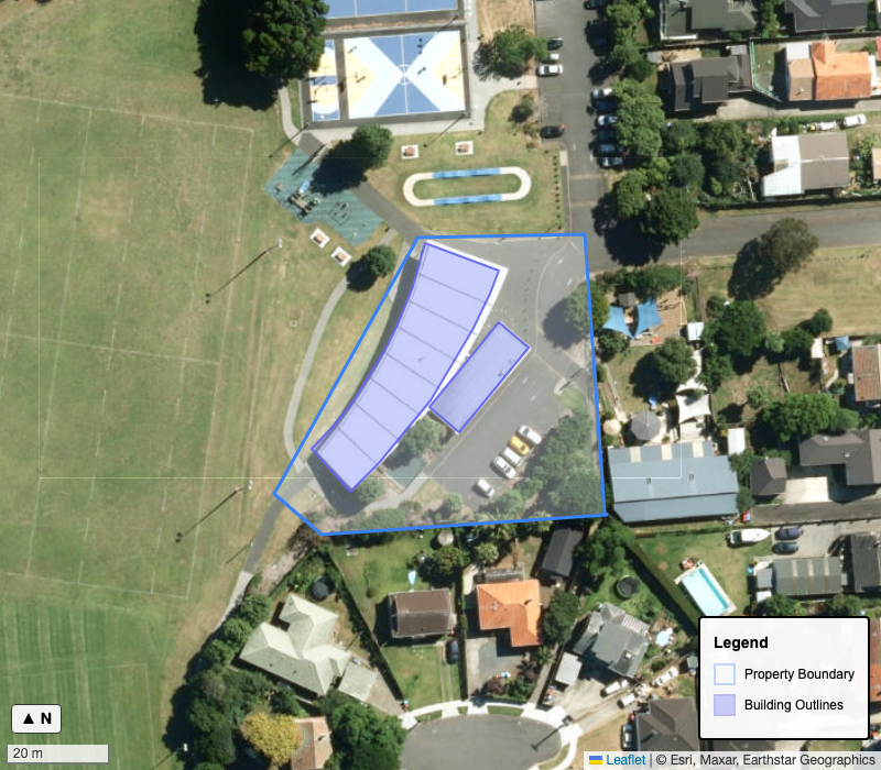
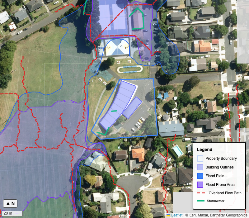
Property boundary and building outlines. Data: LINZ / Auckland Council. Indicative only.
Your property is in the Residential - Single House Zone that has specific development rules.
Caution: Because of the 'Special Character' overlay, external changes to the front of your house will likely need a resource consent to ensure they match the neighborhood style.
Good news: Based on known building footprint, you have approximately 109 m² of remaining footprint allowance for extensions or a garage (subject to hard-surface limits—see Buildability section).
Renovation is possible, but design care is needed to respect the zoning rules and applicable overlays.
Indicative only. This report uses automated analysis of public data. Always verify findings with a Land Information Memorandum (LIM), Dial Before You Dig report, and qualified professional advice before making decisions.
Zone rules and what they mean for your property
The Single House Zone is a low-intensity residential zone primarily designed for single detached dwellings. For homeowners, this means you have good flexibility for extensions, renovations, and accessory buildings like garages, with clear rules about site coverage (35%), height limits (8m), and setbacks from boundaries.
Buildings are limited to 8m in the Single House Zone. This keeps development generally to a low-rise form and supports the established detached-house character of the neighbourhood.
View in Unitary Plan(H3.6.1)Site coverage is capped at 35% in the Single House Zone. This preserves spacious sections, leaves room for gardens, and supports the lower-density character of the neighbourhood.
View in Unitary Plan(H3.6.3)A 3m front yard and 1m side and rear yards apply in the Single House Zone. These setbacks help maintain street character, separation between homes, and access to sunlight.
View in Unitary Plan(H3.6.8(1))One dwelling per site remains the default residential outcome in the Single House Zone. This keeps the zone focused on detached housing rather than more intensive redevelopment.
View in Unitary Plan(H3.4.1)Impervious area is capped at 60% in the Single House Zone. This helps manage stormwater while still allowing for driveways, paved areas, and accessory buildings.
View in Unitary Plan(H3.6.9)At least 40% of the net site area should remain landscaped in this sample Single House scenario. This pairs with coverage and impervious limits to keep garden character.
View in Unitary Plan(H3.6.11(1))Detailed planning standards grouped by topic, with the relevant AUP references alongside them for easy follow-up.
Standard
Maximum Building Height
Requirement
Buildings must not exceed 8 metres. This maintains the low-density, single-storey to two-storey character of the zone. Tall or bulky forms are restricted to protect neighbourhood amenity.
Applies when: new build
Clause
Standard
Height in relation to boundary
Requirement
Recession planes and height in relation to boundary protect neighbour outlook, daylight, and privacy. Second-storey additions often need these planes checked even when under the 8m height limit.
Applies when: new build, alterations affecting height or shape
Clause
Standard
Minimum Yards (Setbacks)
Requirement
Front yard: 3m from the road boundary. Side and rear yards: 1m minimum. These setbacks maintain the open, spacious streetscape character of single house neighbourhoods.
Applies when: new build
Standard
Maximum Site Coverage
Requirement
Buildings can cover up to 35% of the site area — the most restrictive of the residential zones. This preserves spacious sections with significant garden areas and maintains the low-density character.
Applies when: new build
Clause
Standard
Maximum Impervious Area
Requirement
Max 60 % (The maximum impervious area must not exceed 60 per cent of the site area.)
Applies when: new build
Clause
Standard
Impervious Surface Limit
Requirement
Maximum 60% of the site can be covered by impervious surfaces (buildings, driveways, paving). This manages stormwater runoff while preserving the garden character of the zone.
Applies when: new build
Clause
Standard
Minimum Landscaped Area
Requirement
Min 40 % (The minimum landscaped area must be at least 40 per cent of the net site area.)
Applies when: new build
Clause
Standard
One Dwelling Per Site
Requirement
Generally only one dwelling is permitted per site. A minor dwelling (up to 65m²) may be added as a permitted activity. Additional dwellings require resource consent as a discretionary activity.
Applies when: new build
Clause
Standard
Minor dwelling (illustrative)
Requirement
For this sample layout: assume a rear minor dwelling pad is concept-tested at ≤65m². On a real site, confirm setbacks to the minor building, stormwater, and parking against the operative activity table and standards.
Applies when: new build (sample scenario only)
Clause
Standard
Earthworks & retaining (illustrative)
Requirement
Steepfall across this sample section may need stepped retaining and drainage details. Check disturbance volumes, stability, and any flood-management overlay conditions before pricing civil works.
Applies when: earthworks (sample note)
Clause
E38.6
Your property is in a 'Special Character Area'. This protects the history of the neighborhood. It doesn't mean you can't modernize! It just means additions should look like they belong—using weatherboards, pitched roofs, and traditional joinery rather than modern monolithic plaster.
Overlays are extra planning rules that sit on top of the base zone. Each one listed below applies to this property.
Verify: Auckland Unitary Plan viewer for full overlay rules.
Design committees, resident societies, or covenants can add extra rules on top of the overlays and zone controls shown above.
Sample design committee / body corporate style checks for this demonstration report only: a search-style blurb would list whether the property is referenced in legacy satellite town design schedules, railway corridor design guidelines, or other Auckland-wide design panels. None of those results are real here—this paragraph exists so you can preview how SiteLenz surfaces “extra governance” layers above the zone rules. A paid report runs the live lookup against Auckland Council datasets and any matched committee or covenant references it finds.
Plan Change 120 may affect this property. Some provisions already have immediate legal effect, while others are still proposed and may change through the hearings process.
Check status
Partial check
Property items found
2
Checked
2 May 2026
This was a partial PC120 check. Treat the current Auckland Unitary Plan section as the operative baseline and check Auckland Council's PC120 viewer before relying on development assumptions.
PC120 spatially identified qualifying matter
The PC120 Property Summary lists - Airspace Restriction Designation for 52C, Waitangi, Road, Onehunga, Auckland, 1061.
What this means: Qualifying matters may constrain intensification or development capacity and should be checked before relying on base-zone assumptions.
PC120 property summary zone information
The PC120 Property Summary lists - Open Space - Sport and Active Recreation Zone for 52C, Waitangi, Road, Onehunga, Auckland, 1061.
What this means: Use this as PC120 viewer context only. The operative Auckland Unitary Plan zone section remains the baseline unless PC120 is confirmed as operative for the relevant control.
The PC120 Property Summary returned property-specific information that needs planner review before it is treated as a report finding. Use the official PC120 map viewer and source documents to confirm whether the returned summary affects this property.
One or more PC120 map layers were unavailable as queryable spatial endpoints when this report was generated. Check the council PC120 map viewer before relying on PC120 assumptions. Treat the current Auckland Unitary Plan section as the operative baseline and use the official PC120 map viewer for the latest proposed/intensification context.
Sources checked: Plan Change 120 Map Viewer, PC120 Property Summary, Plan Change 120 Zones, No Rezoning Proposal, No Intensification Proposal, Walkable Catchment - Policy 3(c), Adjacent to Centre - Policy 3(d), Coastal Erosion Immediate Legal Effect, Coastal Inundation Immediate Legal Effect, Infrastructure Combined Wastewater Network Control, Rapid Transit Stops - Policy 3(c), Height Variation Control, Historic Heritage Overlay Extent of Place, National Grid Corridor Overlay, Significant Ecological Areas Overlay Terrestrial, Outstanding Natural Features Overlay, Outstanding Natural Landscapes Overlay, Sites and Places Of Significance To Mana Whenua Overlay, Regional Maunga Viewshafts And Height and Building Sensitive Areas Overlay, Local Public Views Overlay, Special Character Area Overlay Residential And Business Retained, Notable Trees Overlay, Notable Group Of Trees Overlay, PC120 Precincts
Unavailable: Plan Change 120 Zones (Published as a tiled PC120 map source in the official viewer; no queryable FeatureServer endpoint has been confirmed.), No Rezoning Proposal (Published as a tiled PC120 map source in the official viewer; no queryable FeatureServer endpoint has been confirmed.), No Intensification Proposal (Published as a tiled PC120 map source in the official viewer; no queryable FeatureServer endpoint has been confirmed.), Frequent Transit Corridor Zoning (Published as a vector tile source in the PC120 register; no queryable FeatureServer endpoint has been confirmed.), Flood Plains Immediate Legal Effect (Published as a vector tile source in the PC120 register; some flood plain information may only be available in the official property summary.), Coastal Erosion Immediate Legal Effect (Published as a tiled PC120 map source in the official viewer; use the PC120 Property Summary fallback until a queryable endpoint is confirmed.), Coastal Inundation Immediate Legal Effect (Published as a tiled PC120 map source in the official viewer; use the PC120 Property Summary fallback until a queryable endpoint is confirmed.), Infrastructure Combined Wastewater Network Control (Published as a tiled PC120 map source in the official viewer; no queryable FeatureServer endpoint has been confirmed.)
Flood risk, ground hazards, coastal conditions, and underground services. Each section includes an embedded map.
Natural hazards and ground conditions that may affect your development. This information is typically found in a PIM (Project Information Memorandum).
What we checked and what you still need
| Topic | Status | Source | What you still need |
|---|---|---|---|
| Land instability | Issues found (open data) | Auckland Council open data (liquefaction / landslide layers) | See Public Hazard Indicators section below |
| Contamination | Issues found (open data) | Auckland Council contaminated-sites catchment and landfill layers | LIM/PIM / HAIL check |
| Coastal / tsunami | Issues found (open data) | Auckland Council coastal hazard and tsunami layers (300m buffer) | See Coastal Hazards section below |
| Existing paving | Unknown | Not available | Site survey / measure on-site |
This table reflects what was checked in this report. Order a PIM (Project Information Memorandum) from Auckland Council for complete official hazard information.
Motorway
Motorway noise context identified approximately 620m away.
Building implications: Road noise may be noticeable at peak periods. Consider acoustic glazing and ventilation if undertaking major alterations.
Why it matters: Noise constraints can affect building costs and buyer perception. Factor into renovation or development planning.
Detailed analysis of flood risks affecting your property based on Auckland Council flood mapping data.
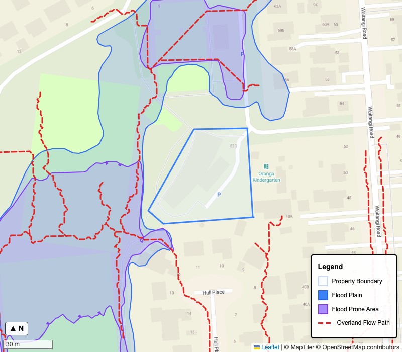
Figure 3: Flood risks and overland flow paths. Data: Auckland Council. Indicative only.
Risk Level: HIGH
Mapped 1% AEP flood plain intersects property
No mapped overland flow paths cross the site.
Mapped flood extent overlaps the site.
Flood Prone Area
3m from boundary
No mapped flood prone area intersects the site, but nearby flood prone areas are present. This may affect development consent and drainage requirements.
Flood plain
On site (0m)
A flood plain crosses the property boundary. This may affect insurance premiums, floor-level design, and how Auckland Council assesses future development.
Property within a mapped flood plain - flood-resilient design and siting assessment are likely required
Resource consent likely required for development
Detailed flood risk assessment required for building consent
Resource consent may be required for development in flood-prone areas.
A flood risk assessment (flood engineer's report) may be required for building consent.
Mitigation may be needed: elevated floor levels, flood-resistant materials, or drainage improvements.
Verify: LIM for flood zone boundaries, historical flooding, and insurance implications.
Coastal inundation, erosion, and tsunami evacuation zones from Auckland Council ArcGIS.
Coastal Inundation
No polygons intersect the site (searched within 300m buffer)
No coastal inundation data found within 500m.
Source: Coastal_Inundation_1_AEP (Auckland Council ArcGIS) · Confidence: high
Coastal Erosion Hazard
No polygons intersect the site (searched within 300m buffer)
No coastal erosion hazard data found within 500m.
Source: CoastalInstabilityAndErosion (Auckland Council ArcGIS) · Confidence: high
Tsunami Evacuation Zone
No polygons intersect the site (searched within 300m buffer)
No tsunami evacuation zone intersects the property within the assessed area (500m).
Source: Tsunami_Evacuation_Zone (Auckland Council ArcGIS) · Confidence: high
Verify: LIM for coastal hazard records, erosion history, sea-level rise projections, and the latest Auckland Emergency Management tsunami evacuation mapping.
Ground hazard and contamination indicator layers from Auckland Council open data (property geometry, plus a 500m landfill proximity search).
| Layer | Intersects? | Class | Confidence |
|---|---|---|---|
| Liquefaction Vulnerability | Yes | Very Low | medium |
| Landslide Susceptibility | Yes | Medium | medium |
| Geotechnical Report Extent | Yes | Medium | medium |
| Contaminated Sites Catchment | Yes | 60 recorded sites | medium |
| Landfill Site | No (1348m) | N/A | medium |
Liquefaction Vulnerability: Property falls within a liquefaction vulnerability zone (Very Low). There is liquefaction vulnerability signal on this site. Liquefaction can cause ground movement during earthquakes. A geotechnical investigation is recommended before significant development. This is a modelled layer — verify with a LIM and site-specific geotech report.
Landslide Susceptibility: Property falls within a landslide susceptibility zone (Medium). There is landslide susceptibility signal on this site. Slope instability can affect foundations and earthworks. Consult a geotechnical engineer before major earthworks or development. This is a modelled layer — verify with a LIM and site-specific assessment.
Geotechnical Report Extent: A geotechnical report extent has been recorded for this area. This indicates prior geotechnical investigation nearby. Request a copy of the relevant report from Auckland Council for site-specific ground condition information.
Contaminated Sites Catchment: Property sits within stormwater catchment "ONE TREE HILL". Auckland Council open data records 60 recorded contaminated sites in this catchment. The site sits within this mapped catchment. This is a catchment-level contamination signal, not parcel confirmation. Treat it as an advisory flag and verify with LIM/PIM records, HAIL checks, and site history before earthworks or redevelopment.
Landfill Site: Auckland Council open data records a landfill site (Historical) approximately 1348m from the property. Purpose recorded: To authorise the discharge of contaminants to ground and groundwater from a closed landfill in accordance with Section 15 of the Resource Management Act 1991.. Nearby landfill can be relevant for settlement, methane, and contamination due diligence. Verify with LIM/PIM records and any geotechnical or environmental reports before major earthworks.
Note: Open-data advisory layers, not official parcel-confirmed records. Verify: LIM/PIM, HAIL review, and site-specific geotechnical or environmental investigation where relevant.
Proximity of public stormwater pipes to your property.
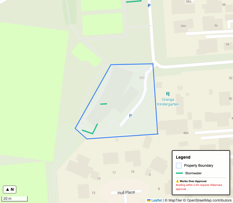
Figure 4: Public stormwater pipes on or near your property. Data: Auckland Council.
Public stormwater pipe crosses property boundary
Nearest Stormwater Pipe
approximately 0m
Dig permit / underground inspection required: Yes — underground pipes have been detected near or crossing your boundary. Dial Before You Dig is recommended before any excavation.
Works Over Approval Required
Building within 2.5m of public stormwater or wastewater pipes may require Works Over approval.
Dial Before You Dig
Before any excavation, request a Dial Before You Dig report to identify all underground services. This is strongly recommended and required by most utility owners before excavation.
Restrictions
Works Over approval required if building within 2.5m of wastewater or stormwater pipes
Dial Before You Dig required before any excavation
Underground inspection may be required for pipes crossing the property
Request a Dial Before You Dig report before any excavation work. This free service identifies underground utilities and is strongly recommended by utility owners before any excavation.
Request reportCheck works over requirements before building within 2.5m of public stormwater or wastewater pipes. This includes foundations, retaining walls, and pools.
Treat pipe locations as indicative. GIS data shows approximate locations. Confirm exact positions with a physical survey before construction.
Open data licenceVerify: Dial Before You Dig before excavating. Treat underground asset locations as indicative until physically confirmed.
Quantified site controls need to be read together. Verify with a planner and survey before relying on these figures.
Additional controls may apply
This estimate reflects standard zone coverage and impervious limits only. Additional precinct, overlay, hazard, covenant, or design-control rules may further restrict height, floor area, or building form. Where such controls apply, planner or specialist review is recommended before relying on this figure.
The buildability limits below are a starting point. Special boards, design committees, resident societies, or covenants may add stricter requirements or change what is practical on site.
Sample design committee / body corporate style checks for this demonstration report only: a search-style blurb would list whether the property is referenced in legacy satellite town design schedules, railway corridor design guidelines, or other Auckland-wide design panels. None of those results are real here—this paragraph exists so you can preview how SiteLenz surfaces “extra governance” layers above the zone rules. A paid report runs the live lookup against Auckland Council datasets and any matched committee or covenant references it finds.
The council limits how much of your land can be covered by buildings, how much can be paved, and how much must remain landscaped.
| Building Footprint (Coverage) | Total Hard Surfaces (Impervious) | Landscaped Area | |
|---|---|---|---|
| Site Area | 780 m² | 780 m² | 780 m² |
| Zone Limit | 35% | 60% | 40% minimum |
| Calculated Requirement | 780 × 35% = 273 m² | 780 × 60% = 468 m² | 780 × 40% = at least 312 m² |
| Current | 164 m² | 164 m² + paving (unknown) | Not measured from current council data |
| Planning Takeaway | 109 m² | Up to 304 m² (less existing paving) | Keep at least 312 m² landscaped |
Key Takeaway: You have approximately 109 m² of building footprint allowance remaining—enough for a significant extension.
Hard Surface Scenarios
Since we don't know your existing paving area, here is how much additional hard surface (driveway, patio, etc.) you could add:
If existing paving is 0 m²
304 m² left
If existing paving is 50 m²
254 m² left
If existing paving is 100 m²
204 m² left
If existing paving is 200 m²
104 m² left
Footprint source: Auckland Council valuation records (building site coverage m²). Maps show LINZ building outlines for visual reference. Verify with a site survey before design work.
Recent local development, amenities, and wider infrastructure context around the property.
Recent building consents lodged within 500m of this property.
| Address | Category | Value Band | Issued | Distance |
|---|---|---|---|---|
| — | RBW - New 25 unit multi-residential deve… | Over $2M | — | 175m |
| — | Garage / Carport | $1M–$2M | — | 303m |
| — | Garage / Carport | Over $2M | — | 324m |
| — | Garage / Carport | $1M–$2M | — | 339m |
| — | Garage / Carport | Over $2M | — | 372m |
| — | Garage / Carport | $1M–$2M | — | 385m |
| — | Application covers the new building, foo… | Over $2M | — | 496m |
Recent high-value consenting activity nearby (indicator only — not a full property consent history). Source: Auckland Council building consents register. Verify consent details directly with Auckland Council.
Neighborhood amenities and day-to-day context that may affect property value and liveability
Schools within 10km of the property, sorted by distance. Enrolment zone status requires verification with individual schools.
Oranga School
420mOnehunga High School
1.4kmWhy it matters: School proximity affects resale demand, family buyer appeal, and enrolment options. Verify in-zone status directly with schools.
Transport Access Score
Medium
Bus stops are within a short walk, with rail access available in the wider Onehunga area.
Nearest Bus Stops
Nearest Train Stations
Why it matters: Good public transport access improves liveability, rental appeal, and supports transit-oriented development values.
Why it matters: Proximity to green spaces enhances lifestyle appeal and perceived property value.
Frontage Speed Limit
50 km/h
Frontage Road
Waitangi Road
Road Safety
No High-Risk Flag
Nearest Intersection
85m
Road Safety Context
4 recorded crashes within km over approximately years
| Radius | Fatal | Serious | Minor | Non-injury |
|---|---|---|---|---|
| 250m | 0 | 0 | 1 | 3 |
| km |
Source: Waka Kotahi Crash Analysis System (CAS). Data covers approximately the last 5 years. High crash counts may indicate busy arterial roads nearby.
Neighborhood Summary
This sample neighbourhood has useful everyday amenity, with open space nearby and public transport options within walking distance. The main due-diligence focus is flood/stormwater design rather than access.
These results reflect available open datasets only — amenities may exist beyond data coverage or search radius.
Verify: Enrolment zones with each school; bus routes with Auckland Transport.
Nearby infrastructure projects, growth corridors, and broader development signals that may affect value and long-term potential
Nearby investment is likely to be incremental rather than transformational. Check Auckland Transport and Auckland Council project pages before relying on this sample.
Onehunga-Oranga intensification context
Within 0.7 km of growth corridor
Source: Auckland Council Identified Growth Corridor Overlay (AUP). Growth corridors signal areas earmarked for future urban development and infrastructure upgrades.
Onehunga transport safety improvements
Auckland Transport
Local stormwater renewals programme
Auckland Council
Source: Te Waihanga National Infrastructure Pipeline (as at 2025-Q4). Projects shown within 50 km of property.
Official property valuation and rates information from Auckland Council
Latest property valuations as at 2024-05-01 (to be used for 2026/2027 rates)
Capital Value (CV)
$1,420,000
Total Property Value
Land Value
$980,000
Value of Land Alone
Improvement Value
$440,000
Value of Buildings
Rates This Year 2026/2027
$3,528.68
Rates Assessment Number: SAMPLE-000123
| Type | Calculation | Amount |
|---|---|---|
| General Rate - Residential | Capital Value $1,420,000 x sample residential rate | $2,284.72 |
| Uniform Annual General Charge | 1 separately used or inhabited part x $604.00 | $604.00 |
| Water Quality Targeted Rate - Non Business | Capital Value $1,420,000 x sample targeted rate | $129.79 |
| Natural Environment Targeted Rate - Non Business | Capital Value $1,420,000 x sample targeted rate | $49.13 |
| Waste Management - Standard Refuse | 1 household refuse service | $270.80 |
| Waste Management - Standard Recycling | 1 household recycling service | $120.32 |
| Climate Action Transport Targeted Rate | Capital Value $1,420,000 x sample targeted rate | $69.92 |
Verify: Auckland Council for current rates, valuation, and property figures. Data: Auckland Council GeoMaps Property, Rate Assessment, and related geometry layers (CC BY 4.0).
A step-by-step checklist for your renovation project.
Locate your boundary pegs
Don't build a fence until you find these!
For this property, use a heritage-experienced Architect or Architectural Designer. Heritage or Special Character controls can materially affect what you can alter and how you present the design.
→ Visit: nzia.co.nz (New Zealand Institute of Architects)
Order a LIM
This report is a preliminary due diligence report. The official LIM is required for legal assurance.
Order the property file
Check historic consent documents, plans, and council records before finalising demolition, structural changes, or additions.
Get geotechnical advice before foundation design
Geotechnical report coverage is recorded on or near the site. Confirm soil, slope, and foundation requirements before locking in detailed design.
Complete contamination due diligence
Check LIM/PIM and HAIL-related records before earthworks, disposal, or redevelopment if contaminated land indicators were detected.
Consider a Council pre-application meeting
Worth doing when overlays, flood constraints, underground services, geotechnical issues, or contamination could affect the consent pathway or design approach.
→ Visit: aucklandcouncil.govt.nz (search for "LIM" and "property file")
SiteLenz is an information service, not a planning, legal, or real estate advisory service.
By using this service, you agree that SiteLenz Ltd is not liable for any decisions you make based on this information.
Official resources that can help you check consents, council records, and underground services before progressing a project.
Auckland Council overview of the full building consent process before you lodge.
Step-by-step guidance for projects that need land-use or development approval.
Get council-held consent records and related documents for the site.
Request the Land Information Memorandum for official property constraints and notices.
Request underground utility plans before excavation or ground works begin.
What was checked and what was unavailable for this report.
Sources: Auckland Council SearchAddress; Auckland Council Landbase Rate Assessment; Auckland Council Landbase Property; Auckland Council Landbase Parcels; Auckland Council Rates Page; Auckland Council Unitary Plan Layers; Auckland Council ArcGIS (Flood & Infrastructure); Auckland Council ArcGIS (Coastal Hazards); Auckland Council ArcGIS (Hazard Proxies); Auckland Council ArcGIS (Building Consents); LRIS Land Use Capability (WFS); Auckland Council Plan Change 120 Map Viewer; LINZ Aerial Basemap; OpenStreetMap; Static sample report mock data; Public property seed: Oranga Community Centre
This report is indicative. Verify with a LIM, PIM, and professional advice before making decisions.
Property boundary, building outlines, flood layers, and stormwater over aerial imagery. Indicative only.
Data: LINZ Aerial / Auckland Council. Indicative only.
This sample report is fictionalised
Get the same level of detail for any Auckland property — enter your address and start with a free snapshot before deciding whether you need the full report.
Get this for your propertyEnter any Auckland address and get your free zoning snapshot. Upgrade to the full report for $39.